Avalanche Lake works because it gives you a complete Glacier experience without requiring an all-day alpine mission. The first minutes feel almost impossibly lush: western red cedars, ferns, boardwalk, and the blue-green power of Avalanche Gorge. Then the lake trail slows the pace and asks for a little more effort. The forest gets quieter, the creek stays close, and the trail earns the final reveal instead of handing it to you from a roadside overlook.
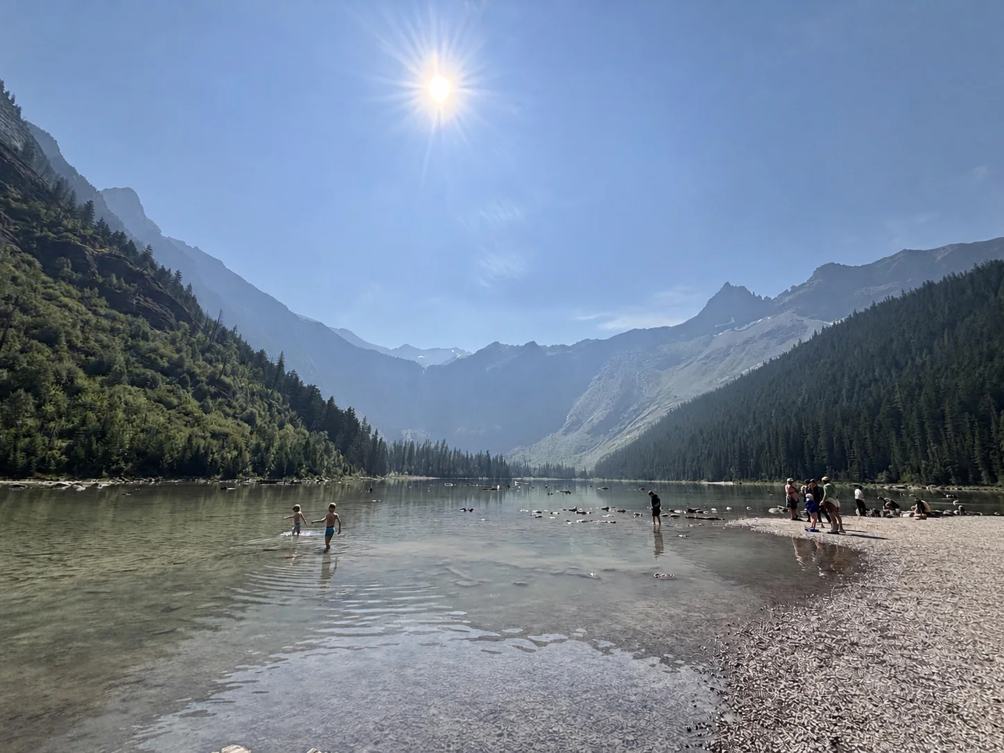
At the lake, the scale changes. The basin is steep, cold, and unmistakably Glacier. Waterfalls show on the far walls when snowmelt is running, the shore is made for a long snack break, and even a busy afternoon still has that high-mountain feeling. That combination is why this is one of the first hikes we would put on a west-side Glacier itinerary.
The honest caveat is that Avalanche Lake is extremely popular. It is not hidden, and it is not a place to expect a private shoreline at noon in July. If you can start early and treat the crowds as part of visiting one of the park's signature places, the hike delivers every time.
The Avalanche parking area is one of the first places to fill along Going-to-the-Sun Road. Summer mornings are best; by late morning, you may find the lot full and traffic circulating. Arrive early, use only designated spaces, and have a backup plan such as the Trail of the Cedars loop at a less busy time.
Restrooms are available in the Avalanche picnic and campground area near the trailhead. Use them before starting; there are no developed services at the lake.
Expect company, especially on summer weekends and between the trailhead, Trail of the Cedars, and Avalanche Gorge. The crowd thins a little on the longer push to the lake, but this is never a solitude hike in peak season. Start early for the best chance at quieter trail and parking.
Going-to-the-Sun Road is paved to the Avalanche area when the road is open for the season. In spring and fall, access can change with snow removal, storms, construction, and road operations. Check the official road-status report before the drive, especially if you are building an itinerary around this hike.
Do not depend on cell service at the trailhead, in the forest, or at the lake. Download maps, save reservation or pass information, and read the current conditions before leaving West Glacier or Apgar.
Pets are not allowed on Glacier National Park trails, including the Avalanche Lake route and Trail of the Cedars. Leave dogs at home and do not assume a well-behaved pet is an exception.
322 Miles from Bozeman, MT. 337 Minutes
From the West Entrance, drive north and east on Going-to-the-Sun Road toward Lake McDonald. Continue roughly 16 miles to the signed Avalanche / Trail of the Cedars area. Turn into the Avalanche Picnic Area and use the designated trailhead parking. The start is adjacent to the picnic area, restrooms, and the Avalanche Campground area.
The road is paved when open, but this is one of Glacier's most popular stops and the lot often fills early. Do not plan on roadside parking. Glacier changes vehicle-access and shuttle programs from year to year, so check the official current conditions page before your visit.
Avalanche Creek is close to the route for much of the hike and the lake is the destination, but none of that means untreated water is safe to drink. Carry enough water for a half-day outing and bring a reliable filter only if you know how to use it. Do not count on finding potable water at the lake.
64 oz consumed per person
The route is well-used and generally easy to follow, but it is not smooth pavement beyond Trail of the Cedars. Expect packed dirt, roots, rocks, mud after rain, and short uneven creekside sections. Early season can mean snow, high water, wet trail, or temporary infrastructure changes. Check the park's trail-status page the day before you go.
Wear trail shoes with grip for roots and wet rocks. Bring a light rain layer and an insulating layer even on a warm day; the forest stays cool, the lake basin can feel breezy, and Glacier weather changes quickly. Bear spray should be immediately accessible, not buried in a pack.
Footwear: Trail Runners or Hiking Shoes
Bring a substantial snack or a light lunch. The lake shore is an obvious place to stop, and the hike is long enough that kids and adults will both hike happier with food in the pack. Keep all food secured and follow Glacier's wildlife and food-storage rules.
Mosquitoes can be noticeable around the creek and lake in early and midsummer, especially in the morning and evening. Bug spray is worth packing, though the moving water and open lake shore can be breezier.
Most of the route is shaded by cedar, hemlock, and conifer forest. The lake shore opens up fully to the sky and surrounding peaks, so bring sun protection even though the approach feels cool.
Treat Avalanche Lake as a day hike. Backcountry camping in Glacier requires a permit and current campsite availability; it is not something to improvise at the lake shore after a casual afternoon hike.
A standard Glacier National Park entrance pass or qualifying annual pass is required. Day hiking does not need a backcountry permit, but overnight trips do. Vehicle-reservation and shuttle rules can change by season, so verify them directly with the park before traveling.
Trail of the Cedars
The short nature trail begins at the same area and provides the boardwalk, old-growth cedars, and Avalanche Gorge experience. It is the right choice for visitors who want a short walk or who are not continuing to the lake.
Avalanche Lake
At the signed junction, continue on the Avalanche Lake Trail for the longer forest climb to the lake. Stay on the established trail and do not create shoreline shortcuts or social paths.
Download the Glacier National Park trail map before entering the park. The route is straightforward in normal conditions, but the park has limited cell service and current closures or bear postings matter more than a navigation app.
The best hiking window is generally late June through September, once Going-to-the-Sun Road is open to the Avalanche area and the lake trail has melted out. July and August offer the most reliable access and the biggest crowds. September can be excellent for cooler temperatures and slightly lighter traffic.
July and August: reliable trail access, long daylight, waterfalls still flowing, and the heaviest parking and trail traffic.
Late June and September: cooler, quieter, and often excellent, but early-season snow, high water, or road restrictions can still affect plans.
Do not treat spring road opening or autumn weather as predictable. Snow, icy trail, high water, and Going-to-the-Sun Road closures can make the normal summer route unsafe or impractical.
Plan on about 5.9 miles round trip for the common route via Trail of the Cedars, with roughly 700 to 800 feet of elevation gain. Most groups need 3 to 4 hours when you include the lake, gorge, and photo stops.
Moderate is the right label. The Trail of the Cedars beginning is easy, but the full lake route is longer and has steady climbing, roots, rocks, and uneven dirt trail. It is very doable for prepared families and newer hikers who are comfortable with the mileage.
The Trail of the Cedars has an accessible boardwalk and firm-surface nature-trail section near the Avalanche area. The trail to Avalanche Lake itself continues beyond that short route on natural, uneven hiking trail and is not an accessible continuation.
No. Pets are not allowed on Glacier National Park trails, including Avalanche Lake and Trail of the Cedars.
It is often the hardest part of the outing. The Avalanche area is one of the park's most popular stops, and the lot can fill early in summer. Arrive early, use designated spaces only, and check the park's current access guidance before you go.
You need a Glacier National Park entrance pass. Day hiking does not require a backcountry permit, but the park's vehicle-reservation and shuttle programs can change season to season. Check the official park site for the rules that apply to your date.
You can reach the shoreline, but the lake is cold mountain water. Treat swimming as a personal cold-water decision, never assume conditions are safe, and keep children close to shore.
Plug 5.9 miles and 757 feet of elevation gain into our free hiking time calculator for a personalized estimate.