You can see the Crazy Mountains from almost anywhere in south-central Montana. They shoot up from the plains like they don’t belong there, an island of sharp granite peaks completely disconnected from the main Rockies. They’re home to the largest population of wolverines in the world, over 40 alpine lakes, and some of the most remote feeling terrain you’ll find in the state. And most people who drive past them on I-90 have never set foot in them.
There’s a reason for that. Getting into the Crazies is not straightforward. The access situation is genuinely confusing, and if you show up without doing your research, there’s a good chance you’ll end up standing in front of a locked gate reading a “No Trespassing” sign. We know because it happened to us.
This post is a practical guide to actually hiking the Crazies. We’ll explain why access is complicated, what changed with the 2025 land exchange, and which trails you can confidently hike right now.


What Makes the Crazies Special
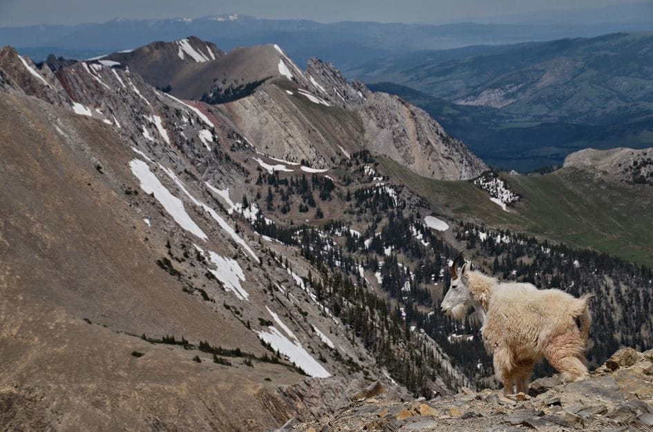
The Crazy Mountains are an island range. Unlike most Montana mountain ranges that connect to the greater Rocky Mountain chain through ridgelines and passes, the Crazies stand alone. They rise sharply out of the prairie south of Harlowton and north of Big Timber, with no connecting ridges to anything else. Crazy Peak tops out at 11,214 feet, and the range has over 20 summits above 10,000 feet packed into a relatively small area about 30 miles long.
The wildlife up here is impressive. Mountain goats, elk, mule deer, black bears, golden eagles, and mountain lions all call the range home. But the headliner is the wolverine. The Crazies support the largest documented wolverine population in the world, which tells you something about how wild and undisturbed this place still is.
The range also holds deep cultural significance. The Crazy Mountains are important vision quest sites and a sacred landscape for the Crow, Salish, Cheyenne, Sioux, and Blackfeet Nations. One of the oldest known Clovis archaeological sites in North America was found nearby. People have been drawn to these mountains for thousands of years.
The Access Problem (And Why It’s Confusing)
This is the part that trips everyone up, and it’s the main reason the Crazies don’t get more visitors.
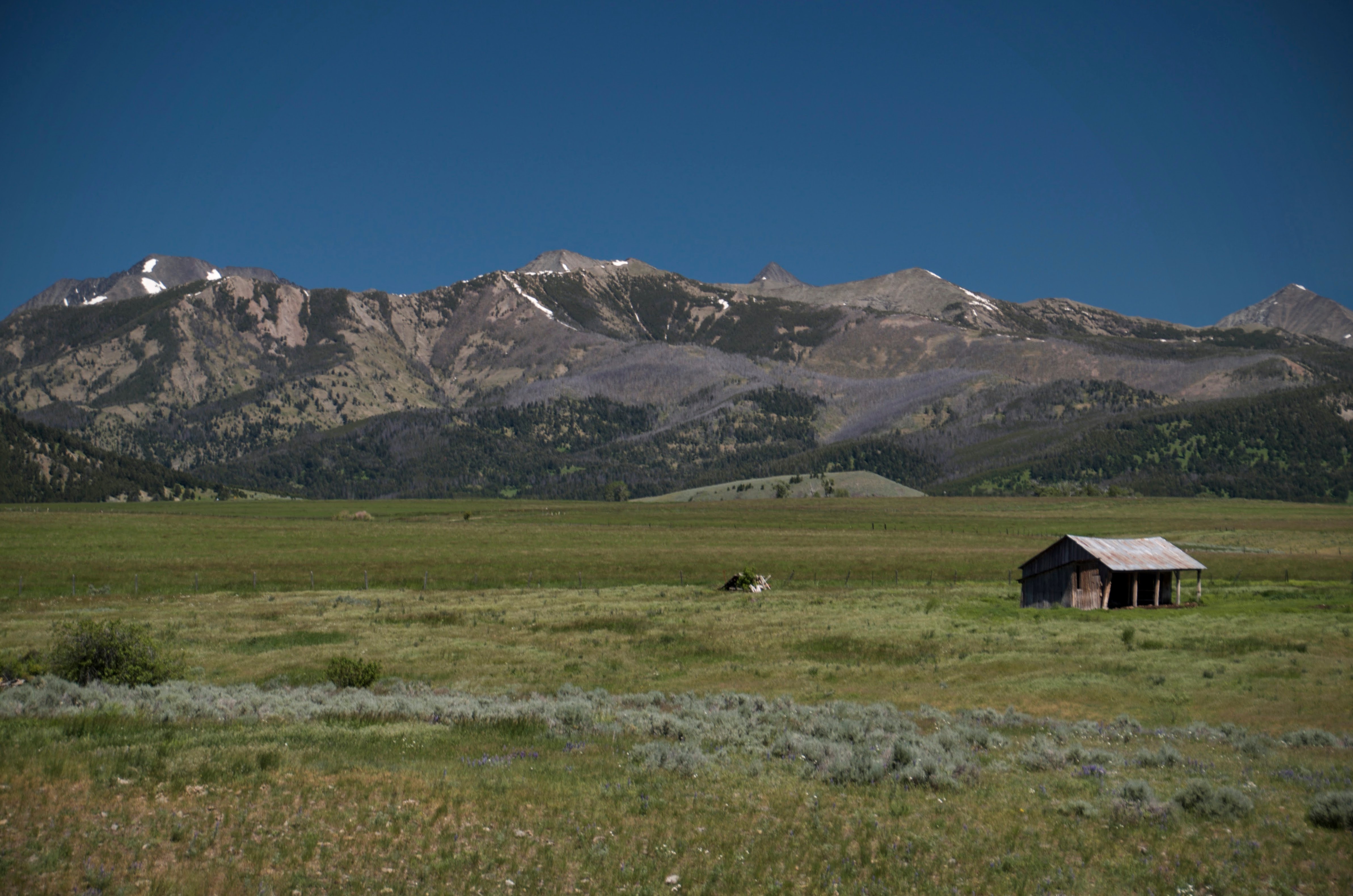
The short version: the land ownership in the Crazies is a checkerboard. If you look at a map, you’ll see alternating square-mile sections of public (Forest Service) land and private land, stacked right next to each other like a chess board. This is a leftover from 19th-century railroad land grants, when the federal government gave companies like the Northern Pacific alternating sections of land as payment for building rail lines across the West. In most mountain ranges, those private sections eventually got consolidated through trades and sales. In the Crazies, the rugged terrain made that consolidation nearly impossible, so the checkerboard stayed.
What this means in practice is that you can follow an official Forest Service trail on your map, hike along for a couple of miles, and then hit a fence with a “Private Property” sign nailed to a tree. Your map says the trail continues. The fence says otherwise. And in Montana, corner crossing (stepping from one public section to another diagonally across a private corner) is generally presumed to be illegal, unlike some states in the 10th Circuit that have ruled differently.

We learned this the hard way. On our second attempt to hike to Campfire Lake, we tried approaching from a different direction than our first successful trip. The trail on our map showed a clear route, but we ended up at a gate that said no trespassing. Our map said one thing, the gate said another, and we honored the sign. We also ran into a huge herd of cattle on that hike, which is pretty common in the Crazies since much of the private land is actively ranched.
The practical takeaway: always verify access using current Forest Service maps and OnX Maps before your trip. Do not rely on older trail guides, outdated apps, or even your favorite mapping software without cross-referencing. The access situation in the Crazies changes, and what was open last year might not be open this year.
The 2025 Land Exchange: What Changed for Hikers
In January 2025, the Forest Service authorized the East Crazy Inspiration Divide Land Exchange, a deal involving more than 15 square miles of property across three counties. On paper, this is a big deal for hikers. The exchange opens up over 2,200 acres of previously inaccessible public land and consolidates 30 miles into a contiguous block. There’s a new 40-mile looped trail system planned, and the Yellowstone Club has agreed to fund construction of a new 22-mile public trail that would replace the disputed East Trunk Trail, starting at Halfmoon Campground.
Here’s where it gets complicated. The Yellowstone Club is not a public interest organization. It’s a private, members-only ski resort for billionaires near Big Sky. The optimistic read is that hikers are finally getting legal access to trails they’ve been blocked from for decades, and that’s worth celebrating. The skeptical read, and the one we lean toward, is that public access was used as leverage to get a land deal done that primarily benefits a private developer. Groups like Wild Montana and Friends of the Crazy Mountains have raised concerns that the long-term protections for the public parcels aren’t strong enough, and that the Yellowstone Club gets development-friendly land consolidation as part of the deal.
The truth is probably somewhere in between, but it’s worth paying attention to. If you want the full backstory on the politics and history behind land access in the Crazies, the book “The Crazies” by Amy Gamerman is a good read. Gamerman is a Wall Street Journal reporter who spent years covering the conflicts in this range.
The practical note for hikers right now: the new trail system is not yet built. Until construction is finished, use the established trailheads and routes listed below.


How to Access the Crazies: The Two Main Sides
West Side (via Cottonwood Creek Road / FR 198)
The nearest town is Clyde Park. From there you’ll head east on Cottonwood Bench Road to reach Forest Road 198 and the Cottonwood Creek Trailhead. A high-clearance vehicle is recommended for the last stretch.
The main trail from this side is Cottonwood Lake Trail #197, a strenuous 10-mile out-and-back to a high alpine lake. The first two miles follow an old closed jeep road, which makes the lower section good for mountain biking if you want to cover ground faster. From the Cottonwood Creek Trailhead, you can also connect to the Trespass Creek Trail and routes deeper into the range, including Campfire Lake.
East Side (via Big Timber Canyon Road / FR 197)
The nearest town is Big Timber, about 23 miles to the southeast. Big Timber Canyon Road takes you to Halfmoon Campground at the end of the road, which functions as the main public access trailhead on this side.
Big Timber Creek Trail #119 heads into the range from here and provides access to Blue and Granite Lakes and eventually deeper into the range. This side tends to get more use from hunters in the fall, and hikers often find it less crowded than the west side during summer.
Featured Trails
Blue Lake: Moderate Day Hike
About 8 miles round trip with 2,100 feet of elevation gain to an alpine lake basin sitting at 8,282 feet below Crazy Peak. There are four other lakes in the same high basin, and this is the most popular base camp for Crazy Peak summit attempts. The fishing is good too. The trail follows Big Timber Creek on an old roadbed for the first couple of miles before climbing up to the lake. This one can get busy on weekends, so go mid-week if you can. Check out our Blue and Granite Lakes trail brief for the full details.
Cottonwood Lake: Strenuous Day Hike or Overnighter
A 10-mile out-and-back with about 2,400 feet of gain to a lake sitting at nearly 9,000 feet in a rugged cirque below Grasshopper Glacier. Expect several creek crossings and plan for the trail to be in rougher shape than what you’re used to in more popular ranges. We climbed over a lot of downed trees covering the trail, and sections can be faint. The cutthroat trout fishing at the lake is worth the effort. Read our full Cottonwood Lake trail brief.
Campfire Lake: Multi-Day Backpack
Accessible from multiple trailheads on both sides of the range, with distances ranging from 7 to 13 miles one-way depending on your route. The lake sits below dramatic ridgelines near the center of the Crazies at about 8,600 feet. Rainbow trout fishing and remote campsites make this one of the best backpacking destinations in the range. Just make sure you verify your access before you go. We have a full Campfire Lake trail brief with details on the route from Cottonwood Creek.
The Full Crazies Crossing: Epic Multi-Day Route
The best way to see nearly all of the range is to do a full traverse or loop. Plan for 21 to 25 miles over at least two nights. The route passes through multiple valleys and alpine lake basins, and you’ll be in the heart of mountain goat country. This is a strenuous point-to-point that requires a vehicle shuttle or key swap, and the trail conditions are rough in places with some scrambling and routefinding required. This is not a groomed trail experience, and that’s part of the appeal.

Practical Planning Info
Season: Mid-July through September is your window. Trails above 8,000 feet hold snow well into June, and early July can still be dicey in a big snow year.
Bears: Grizzlies are present in the Crazies. Carry bear spray, know how to use it, and hike in groups when possible. Read our bear spray guide if you need a refresher.
Trail conditions: Don’t expect the well-maintained trails you’ll find in the Gallatin Range or the Beartooths. The Crazies see less maintenance, and you should expect downed trees, faint trail sections, and creek crossings without bridges.
Maps: Forest Service maps and OnX are essential given the checkerboard ownership. Do not rely on older trail guides or apps alone. Verify access before every trip.
Nearest towns: Big Timber is your base for the east side. Livingston or Clyde Park for the west side. Stock up on supplies before you head in because there’s nothing once you leave town.
No designated wilderness: The Crazy Mountains are not formally wilderness-protected, so motorized use is allowed on some routes. Check current regulations before you go if you’re looking for a non-motorized experience.
Why the Crazies Are Worth the Extra Homework
The Crazies are not the easiest range to hike in Montana. The access is complicated, the trails are rough, and you have to do more planning than you would for a trip to Hyalite or the Bridgers. But that extra homework is exactly why the Crazies feel the way they do. You won’t run into a line of hikers at the trailhead. You won’t hear music from a Bluetooth speaker at the lake. You will feel like you’re actually in the mountains, away from everything, in a range that most people only see from their car window.
The wolverines have the right idea. There’s a reason they chose the Crazies.