The most common question before a Bozeman trip is some version of: what’s a hike that isn’t too hard? The area has a real range of options, and you do not need to climb 3,000 feet or spend a full day in the car to get a worthwhile morning outside.
This guide covers 9 hikes near Bozeman and the Gallatin Canyon that work for beginners, families, and anyone who wants something short and rewarding. A few are rated moderate on their individual trail pages because the elevation gain is real, but they are short, close to town, and manageable for people who are reasonably active. Where the difficulty bumps up, the individual sections say so plainly.
One thing worth knowing before you go: even easy hikes here are at elevation. Bozeman sits at 4,820 feet and most trails climb from there. If you are coming from sea level, take it easier than you think you need to on the first day, drink more water than usual, and you will adjust quickly.

Best Easy Hikes Near Bozeman (Quick Picks)
- Peets Hill / Burke Park (1 mi, Easy): Half a mile from downtown, no driving required, 360-degree views of the Gallatin Valley. One of the best off-leash dog areas in Bozeman.
- Palisade Falls (1.1 mi, Easy): A paved, wheelchair-accessible trail to an 80-foot waterfall in Hyalite Canyon. The easiest waterfall hike near Bozeman by a wide margin.
- Grotto Falls (2.5 mi, Easy): The better Hyalite waterfall if you want to get in the water. A shaded trail ends at a pool you can wade in all summer.
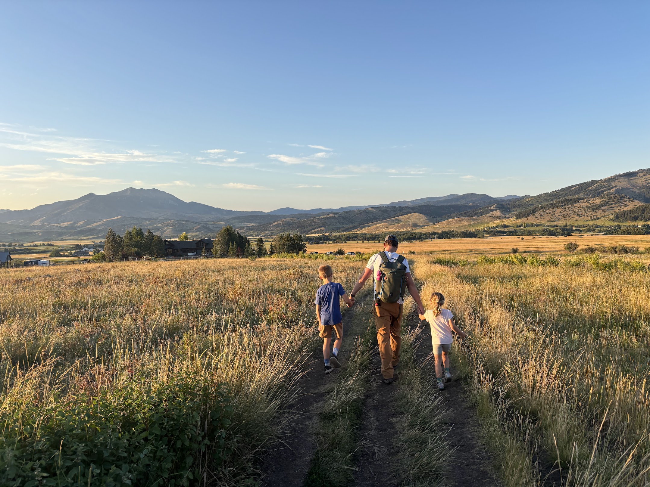
- Sourdough / Bozeman Creek Trail (go as far as you want, Easy): An old road grade along the creek with no steep sections. Turn around whenever you feel like it. The best trail on this list for young kids.
- The M (3 mi, Moderate): Steep and genuinely crowded, but Bozeman’s most iconic trail and worth doing once. The view of the Gallatin Valley from the top explains why people move here.
Comparison Table
| Hike | Distance | Elevation Gain | Difficulty | Best For |
|---|---|---|---|---|
| Peets Hill | 1 mi | 102 ft | Easy | Quick views, off-leash dogs |
| Palisade Falls | 1.1 mi | 319 ft | Easy | Families, wheelchair access |
| Kirk Hill | 1.6 mi | 650 ft | Moderate | Shaded summer hike |
| Ousel Falls | 1.6 mi | 400 ft | Easy | Big Sky day trip |
| Drinking Horse | 2.3 mi | 700 ft | Moderate | Views without The M crowd |
| Grotto Falls | 2.5 mi | 285 ft | Easy | Kids, swimming |
| Pine Creek Falls | 2.5 mi | 460 ft | Easy | Yellowstone road trip stop |
| The M | 3 mi | 805 ft | Moderate | Bozeman’s signature hike |
| Sourdough / Bozeman Creek | Variable | Gradual | Easy | Flexible distance, dogs |
All 9 Hikes
Peets Hill / Burke Park
Distance: 1 mile | Elevation Gain: 102 ft | Drive from Bozeman: 3 minutes
Peets Hill is half a mile from downtown and part of the Main Street to Mountains trail system that links Bozeman’s core to the surrounding open spaces. If you’re staying near downtown, you might be able to walk from your front door.
The trail climbs briefly from the Church Avenue trailhead before leveling into a wide gravel ridgeline walk with views of the city and every mountain range surrounding the valley. At the top, a Native American Medicine Wheel with metal silhouette benches aligns with actual peaks in the Gallatin Valley, and it is worth spending a few minutes with. If you want a flat route, park at the Josephine Drive lot instead, which connects directly to the accessible loop on the ridge without touching the steep section.
Off-leash dogs are allowed throughout the park and it shows. The trail runs from early morning through sunset seven days a week, heavy on runners, dog walkers, and photographers at golden hour. Go early on weekends if you want more breathing room.
Full guide to Peets Hill / Burke Park
Sourdough / Bozeman Creek Trail
Distance: Go as far as you want (up to 18 mi round trip) | Elevation Gain: Gradual throughout | Drive from Bozeman: 15 minutes
Sourdough Canyon follows an old road grade along Bozeman Creek, which means the climb is smooth and consistent from start to finish, no steep pitches, no technical sections, no moments where you’re wondering if you’re still on the trail. Go two miles out and turn around, or three miles to the bathroom at the mid-point turnaround, or all the way to Mystic Lake at nine miles out. The distance is entirely up to you.
The creek runs alongside you for most of the walk and the canyon is shaded for much of the way. In fall it is one of the better spots near town to catch the changing leaves. Keep your eyes open for moose.
Wide enough for groups walking side by side, shared with mountain bikers who spread out enough over the distance that it is never an issue, and an easy yes for dogs. Tennis shoes are fine for the first few miles.
Full guide to Sourdough / Bozeman Creek Trail
Kirk Hill Natural Area
Distance: 1.6 mi | Elevation Gain: 650 ft | Drive from Bozeman: 12 minutes
Kirk Hill is sometimes listed as easy based on the short distance, and that undersells the grade. The trail gains 650 feet in well under a mile and the climb starts at the gate, no warm-up. There is nothing technical here, but the incline is sustained from the first step.
The reason to choose Kirk Hill is shade. Old-growth Douglas fir and spruce cover the trail almost entirely, which makes it noticeably cooler than the exposed ridgelines around town. When The M is a dusty, sun-baked slog in July, Kirk Hill is a different experience. Three numbered loops branch off a shared main stem. Loop 1 goes to a bench with valley views. Loop 2 winds through denser forest past stick lean-tos hikers have built over the years. Loop 3 is the shortest circuit if you’re short on time. Most people string two loops together for a 1.5 to 2-mile outing, about 45 minutes to an hour.
No bikes allowed, so it’s hikers and runners only. Dogs must be on leash.
Full guide to Kirk Hill Natural Area
The M Trail
Distance: 3 mi | Elevation Gain: 805 ft | Drive from Bozeman: 13 minutes
The M is Bozeman’s most recognizable landmark, a letter on the side of Baldy Mountain spelled out in limestone rocks, and the trail to it is the most popular hike in the area. The view of the Gallatin Valley from the top is the one you have seen in every Bozeman photo.
Two routes go up: the western trail is longer and more gradual, the eastern route is a straight shot and steeper. Take the western route if you want a more manageable climb. Either way, it is steep from start to finish. The moderate rating is accurate. Go early. By 9 AM on a summer weekend the parking lot is full and the trail is a steady stream of people, dogs, and strollers. Show up before 8 and you will have a different experience entirely.
Bring water. The trail is exposed and there is no shade.

Drinking Horse Mountain
Distance: 2.3 mi | Elevation Gain: 700 ft | Drive from Bozeman: 10 minutes
Drinking Horse is directly across Bridger Canyon Road from The M trailhead. If The M parking lot is already full when you pull in, Drinking Horse is the right call, and the views from the summit are honestly better. You can see The M from the top, the full Bridger Range, and the Gallatin Valley spread out below.
The trail is a loop, so you go up one side and down the other without retracing your steps. The left route has switchbacks and shade. The right route is more gradual but exposed on a west-facing slope. Large boulders at the summit make a good lunch spot, and the stick shelters hikers have built up there over the years tend to be a hit with kids.
At 700 feet of gain over 2.3 miles, this is moderate, not easy. But it is short, 10 minutes from downtown, and consistently less crowded than The M. No bathroom at the trailhead. Take care of business before you leave Bozeman, or use the pit toilet across the road at The M trailhead.
Full guide to Drinking Horse Mountain
Palisade Falls
Distance: 1.1 mi | Elevation Gain: 319 ft | Drive from Bozeman: 42 minutes
Palisade Falls is in Hyalite Canyon about 20 miles south of Bozeman, and it is the easiest waterfall hike in the area by a significant margin. The trail is paved from the parking lot to the falls, it is wheelchair accessible, there are picnic tables at the trailhead, and the falls drop 80 feet off a volcanic rock wall that you can reach in about 15 minutes. TripAdvisor ranks it in the top five things to do in the Bozeman area, which tells you exactly what to expect on the trail by 10 AM.
The trail is short enough that you could do it in jeans and sneakers and be just fine. Go in the morning to beat the crowds, and bring the kids because the falls are impressive up close.
Be Advised: Hyalite Canyon Road closes annually from April 1 to May 15. You cannot reach this hike by car during that window.

Grotto Falls
Distance: 2.5 mi | Elevation Gain: 285 ft | Drive from Bozeman: 43 minutes
Grotto Falls is one canyon over from Palisade Falls and gets a fraction of the foot traffic. The trail runs alongside Hyalite Creek through dense spruce and fir forest on a wide, gently graded path, ending at a wide cascade that drops into a clear, shallow pool. On a hot day in July, this is the hike to do.
The pool is the reason to choose Grotto Falls over Palisade. Clear, shallow water with a rocky shoreline, plenty of room to spread out, and kids can wade in it comfortably all summer. Bring a towel and a snack and plan to stay awhile. The trail is confirmed accessible, though the natural gravel surface gets soft after rain in a way that paved Palisade Falls does not.
Parking at the Grotto Falls trailhead is limited. Arrive early on weekends or you may end up parking down the road and walking in.
Be Advised: Hyalite Canyon Road closes annually from April 1 to May 15.

Ousel Falls
Distance: 1.6 mi | Elevation Gain: 400 ft | Drive from Bozeman: 1 hour
Ousel Falls is right in Big Sky, about an hour south of Bozeman through the Gallatin Canyon. The drive on US-191 through the canyon is a good trip on its own, following the Gallatin River through tight rock walls with the road and river running side by side for miles.
The trail drops through dense forest, crosses a bridge over the South Fork of the Gallatin, and ends at a 100-foot waterfall. The downhill-in, uphill-out design means you’ll do the harder work on the way back, so save some energy. Dogs must be on leash. This is BSCO-managed land and they enforce the rule.
On the drive home, The Riverhouse BBQ on US-191 just south of Big Sky has good barbecue and a patio over the river. Worth the stop.
Pine Creek Falls
Distance: 2.5 mi | Elevation Gain: 460 ft | Drive from Bozeman: 50 minutes
Pine Creek Falls is in Paradise Valley near Livingston, about 50 minutes from Bozeman. The trail follows Pine Creek through lodgepole forest on a flat, well-beaten path before ending at a 100-foot multi-tiered waterfall. You can reach it in 30 to 40 minutes and be back at the car in under 90 minutes, which makes it a natural stop on any Paradise Valley or Yellowstone trip.
The payoff is big for the effort required. The falls are loud and impressive from multiple angles, and the base gives you room to explore. Dogs are allowed off-leash and there is creek access the entire way.
Full guide to Pine Creek Falls
Easy Hikes Under 3 Miles Near Bozeman
All of these are 3 miles or less round trip:
- Peets Hill — 1 mi, Easy, 102 ft gain
- Palisade Falls — 1.1 mi, Easy, 319 ft gain
- Ousel Falls — 1.6 mi, Easy, 400 ft gain
- Kirk Hill — 1.6 mi, Moderate, 650 ft gain
- Drinking Horse Mountain — 2.3 mi, Moderate, 700 ft gain
- Grotto Falls — 2.5 mi, Easy, 285 ft gain
- Pine Creek Falls — 2.5 mi, Easy, 460 ft gain
- The M — 3 mi, Moderate, 805 ft gain
Easy Hikes With Waterfalls Near Bozeman
Every trail on this list ends at a waterfall:
- Palisade Falls (1.1 mi) — 80-ft drop, paved trail, wheelchair accessible, Hyalite Canyon
- Grotto Falls (2.5 mi) — Wide cascade with a wading pool at the base, Hyalite Canyon
- Ousel Falls (1.6 mi) — 100-ft drop, dense forest trail, Big Sky
- Pine Creek Falls (2.5 mi) — 100-ft multi-tiered falls, Paradise Valley
Best Easy Hikes for Kids Near Bozeman
These work well with younger kids:
- Palisade Falls — Short, paved, picnic tables at the trailhead, impressive waterfall payoff
- Grotto Falls — The wading pool at the base is the main event for kids
- Sourdough / Bozeman Creek Trail — Flat the entire way, turn around whenever, bathroom at the 3-mile mark
- Peets Hill — Ten minutes from downtown, 1 mile, the Medicine Wheel installation at the summit is worth seeing
- Drinking Horse Mountain — Short loop with stick forts at the summit that kids tend to find on their own
Local Tips for Easy Hiking Near Bozeman
When to go: Late June through mid-September covers the full list. Lower-elevation trails around town, The M, Drinking Horse, Kirk Hill, and Peets Hill, are typically accessible from late May in most years. Hyalite Canyon Road closes April 1 to May 15, which means Palisade Falls and Grotto Falls are not accessible by car until mid-May.
Where crowds build up: The M parking lot fills by 9 AM on summer weekends. Palisade Falls runs steady from mid-morning through late afternoon all summer. Both are still worth doing, just go early. Grotto Falls, Kirk Hill, and Drinking Horse are consistently quieter and all three are close to town.
What most visitors get wrong: Showing up to The M at 10 AM expecting a parking spot. Not knowing that Hyalite Canyon Road closes in spring. Assuming that tennis shoes are always fine on every trail, when microspikes are genuinely necessary at Kirk Hill and The M from December through March. And expecting that easy means flat here, because most trails gain meaningful elevation even when they are short.
Permits: No day hiking permits are required for any trail on this list. No fees for any of these trails.
Frequently Asked Questions
What is the easiest hike near Bozeman?
Peets Hill is the most accessible hike near Bozeman, with 1 mile of trail, 102 feet of elevation gain, and a trailhead half a mile from downtown. No driving required. For the easiest waterfall hike, Palisade Falls in Hyalite Canyon is paved, wheelchair accessible, and 1.1 miles round trip.
Are there beginner hikes near Bozeman?
Yes. Peets Hill, Palisade Falls, Grotto Falls, Sourdough / Bozeman Creek, and Ousel Falls are all appropriate for beginners. They are short, well-marked, require no navigation skills, and can be completed in comfortable shoes. The main thing to account for is elevation, since even easy hikes here start at around 4,800 feet.
What hikes near Bozeman are good for kids?
Palisade Falls (paved trail, picnic tables at the trailhead), Grotto Falls (wading pool at the base), and Sourdough / Bozeman Creek (flat, flexible distance, bathroom at the 3-mile mark) are the most consistent picks for younger kids. Peets Hill works well for a quick urban outing. Drinking Horse and The M work for older kids who want a real climb.
Are there easy hikes near Big Sky, Montana?
Ousel Falls is the most accessible easy hike near Big Sky, with a 1.6-mile round trip through dense forest to a 100-foot waterfall. The trailhead is right in Big Sky town. Dogs must be on leash as this is Big Sky Community Organization-managed land.
When is the best time for easy hiking near Bozeman?
July through September is the most reliable window for the full list. Lower-elevation trails around town are typically accessible from late May. Hyalite Canyon Road closes April 1 to May 15, which means Palisade Falls and Grotto Falls are not drivable during that period.
Do I need a permit for day hiking near Bozeman?
No. Day hiking in the Gallatin National Forest and surrounding wilderness areas does not require a permit. There are no fees for any trail on this list.
Are dogs allowed on easy hikes near Bozeman?
Most trails on this list welcome dogs. Peets Hill and Sourdough / Bozeman Creek allow dogs off-leash. The M, Drinking Horse, Kirk Hill, Palisade Falls, Grotto Falls, and Pine Creek Falls allow dogs on-leash or off-leash within national forest rules. Ousel Falls requires dogs on leash at all times, as it is managed by the Big Sky Community Organization rather than the Forest Service.