Hiking the wrong trail in the wrong season in Montana means one of three things: post-holing through waist-deep snow, churning up muddy trails that will take years to recover, or standing at the base of a peak wondering why you didn’t check whether the access road was open. The terrain here is too variable for a one-size approach to trail selection.
Every trail on this site has an optimal window, and most of them also have windows where you genuinely shouldn’t be there. Here’s the logic behind each season and which trails to focus on when.
Spring: The Science of the Melt and Trail Integrity
Spring in Montana is not one season. It’s three seasons competing at the same elevation simultaneously, and the deciding factor is which direction a slope faces.
South and west-facing hillsides receive more direct solar radiation than shaded north-facing drainages. That difference in sun exposure can mean the soil on one side of a ridge is bone dry while the other side is still under two feet of snow. The practical result: in March and April, aspect matters more than elevation when you’re choosing a trail. A 5,000-foot south-facing slope will often be hikeable a month before a 4,500-foot north-facing canyon.

The other critical spring factor is the freeze-thaw cycle. Overnight temperatures drop below freezing and daytime temperatures climb into the 40s and 50s, turning the top layer of soil into deep, sticky clay. Hiking through it causes rutting and soil compaction that can last for years. What’s worse is what happens when hikers try to walk around the mud: that’s how trails get permanently widened into braided messes. Walk through the mud or turn around and come back when it’s dry. There’s no third option here.
Lower elevations are also winter range for elk and deer through April and well into May. The animals are recovering from caloric deficits after a hard winter, and repeated human pressure on those ranges adds stress at exactly the wrong time. The fortunate thing is that the trails that work best in spring, the heavily used front-country ridgelines close to town, are already factored into the local wildlife picture.
Best spring trails:
Drinking Horse Mountain (2.3 mi, Moderate) is the first call in early spring. The west-facing slope dries out faster than almost any other trail near Bozeman, and the 700-foot loop gives you good views of the Bridger Range and Gallatin Valley without dragging you into muddy north-facing terrain. It’s quieter than The M, which sits directly across Bridger Canyon Road.
The M Trail (3 mi, Moderate) is exposed and south-facing on a limestone hillside, which means it sheds moisture fast and stays dry. It’s the busiest trail close to town, and for good reason. Show up before 8 AM if you want the trail to yourself.
Kirk Hill (1.6 mi, Moderate) off South 19th is a dense Douglas fir and aspen loop that works well once the canopy terrain starts to dry. The caveat is that same shade holds mud and ice much longer than the open ridgeline trails. Wait until late April or early May before heading up here, and bring traction devices if overnight freezing is still happening.
Once Hyalite Canyon Road opens on May 15, Grotto Falls (2.5 mi, Easy) is one of the first waterfall hikes in good shape. Short, forested, and well-maintained, and you can walk behind the falls when the flow is high.
Pine Creek Falls (2.5 mi, Easy) in Paradise Valley sits at a low enough elevation to dry quickly, and the waterfall is at its most impressive during spring runoff. A good stop on the way toward the Yellowstone north entrance.
Summer: Chasing the Alpine Window
By July the valleys are hot. Bozeman can hit 90 degrees in late summer, and the combination of dust, sun, and trail crowds at lower elevations is exactly what most people moved here to escape.
The environmental lapse rate drops temperature roughly 3.5 degrees for every 1,000 feet of elevation gained. When it’s 95 in the Gallatin Valley at 4,700 feet, the alpine lakes sitting at 8,500 to 9,000 feet are running around 70 degrees. The logic for chasing elevation in summer is about more than aesthetics.

The alpine window is narrower than most people expect. Above 8,500 feet, most trails don’t clear of snow and dangerous ice bridges until mid-July in an average year. By mid-September, early storms can close the same routes. You get roughly eight to ten weeks, sometimes less. The wildflower bloom follows the snowmelt, and mid-July is the peak biological window for alpine meadows. What you’ll see at Beehive Basin or on the ridge above Sacagawea Peak during that window is worth arranging your summer around.
Best summer trails:
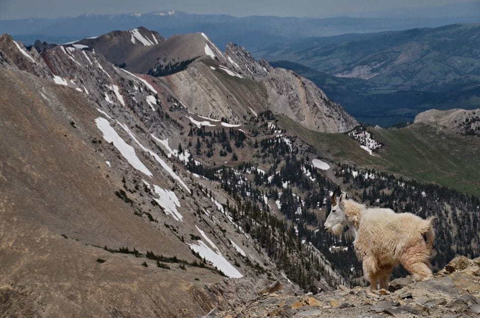
Fairy Lake to Sacagawea Peak (4.5 mi, Strenuous) reaches 9,665 feet, the highest point in the Bridger Range. The basin below the summit holds snow into July most years, and by mid-July the mountain goats are shedding their winter coats and the wildflowers are at peak bloom around the talus. The Fairy Lake road gate opens July 1, so there’s no early access by car.
Emerald and Heather Lakes (11 mi, Moderate) in Hyalite Canyon is a long steady climb past waterfalls to two alpine lakes at 9,188 feet. The lake basin is at its greenest from late July through August, with good fishing in both lakes. Hyalite Canyon Road reopens May 15, but hold off on the upper lakes until July when the snow has cleared.

Beehive Basin (6.3 mi, Moderate) near Big Sky has the wildflower meadows and the granite cirque with Lone Peak above it. It starts at 7,944 feet, which means it opens earlier than some high routes, and the views at the lake match what the photos show. The crowds match the reputation, so start early.
Hyalite Lake (12 mi, Moderate) is the crown of Hyalite Canyon, passing ten waterfalls on the way to a high alpine lake ringed by rocky cliffs. It’s a full-day commitment and the best first big-day hike near Bozeman.
Mount Blackmore (11.6 mi, Strenuous) at 10,154 feet is the hardest peak in Hyalite. The final ridge section is exposed and off-trail. Check conditions before going, as late snow can linger on the upper terrain well into June even in normal years.
For more options across the full range of terrain around Bozeman: Garnet Mountain (8 mi, Strenuous) climbs to a historic fire lookout with views in every direction, Lava Lake (5.5 mi, Moderate) in the Spanish Peaks is a reliable moderate day hike to a clear alpine lake, Windy Pass (6.9 mi, Moderate) accesses the Gallatin Crest through wide open meadows, and The Beaten Path (26.6 mi, Moderate to Strenuous) is the multi-day backpacking traverse across the Absaroka-Beartooth with 27 named lakes along the route.
If you want to get away from the Bozeman orbit entirely, the Crazy Mountains rise out of the plains east of Livingston with far less foot traffic than comparable terrain closer to town. Blue and Granite Lakes (9 mi, Moderate) is the starting point, and Campfire Lake (6.9 mi, Strenuous) and Cottonwood Lake (8.2 mi, Strenuous) take you deeper into a range most visitors never find.
Fall: Phenology, Frost, and Foraging
Fall hiking in Montana has something you won’t find anywhere else in the northern Rockies: the Western Larch. This is the only conifer in North America that drops its needles, and in October it turns a saturated gold that stands out from the surrounding evergreens in a way that registers as slightly wrong until you figure out what you’re looking at. The Larch groves in the Swan Valley and in certain Gallatin Range drainages light up for two to three weeks in late September and early October.
The color change itself is a function of leaf senescence. As days shorten and temperatures drop, deciduous trees stop producing chlorophyll, which reveals the yellow and orange carotenoid pigments that were present all along. Aspen groves in canyon drainages go bright gold, and the window between the first hard frost killing the high brush and the aspens reaching peak color is narrow enough that showing up at the right time takes some attention.

Fall also means the ungulate rut, running roughly from September through October for elk and moose. Both species are highly active and sometimes aggressive during this period. Trails with good sightlines reduce the chance of a close encounter at a bad moment. Make noise and give animals room. This window also overlaps with Montana’s general rifle season, which typically starts in late October. Wearing orange on national forest trails during rifle season is not optional.
Best fall trails:
Ousel Falls (1.6 mi, Easy) near Big Sky is shaded, heavily forested, and at a low enough elevation to stay accessible well into November most years. The South Fork of the West Fork of the Gallatin runs full through fall, the canopy turns in late September, and the 100-foot falls surrounded by changing leaves is one of the better easy fall hikes in the area. The drive down the Gallatin Canyon on US-191 is worth the trip on its own in October.
Storm Castle Peak (5 mi, Strenuous) in the Gallatin Canyon gives you a wide-angle view of the river canyon and surrounding ridges from a limestone summit that genuinely looks like castle battlements. The aspens on the lower switchbacks turn gold in late September. The trail runs hot and exposed in midsummer, but conditions in September and October are much more manageable before the upper switchbacks get their first snow.
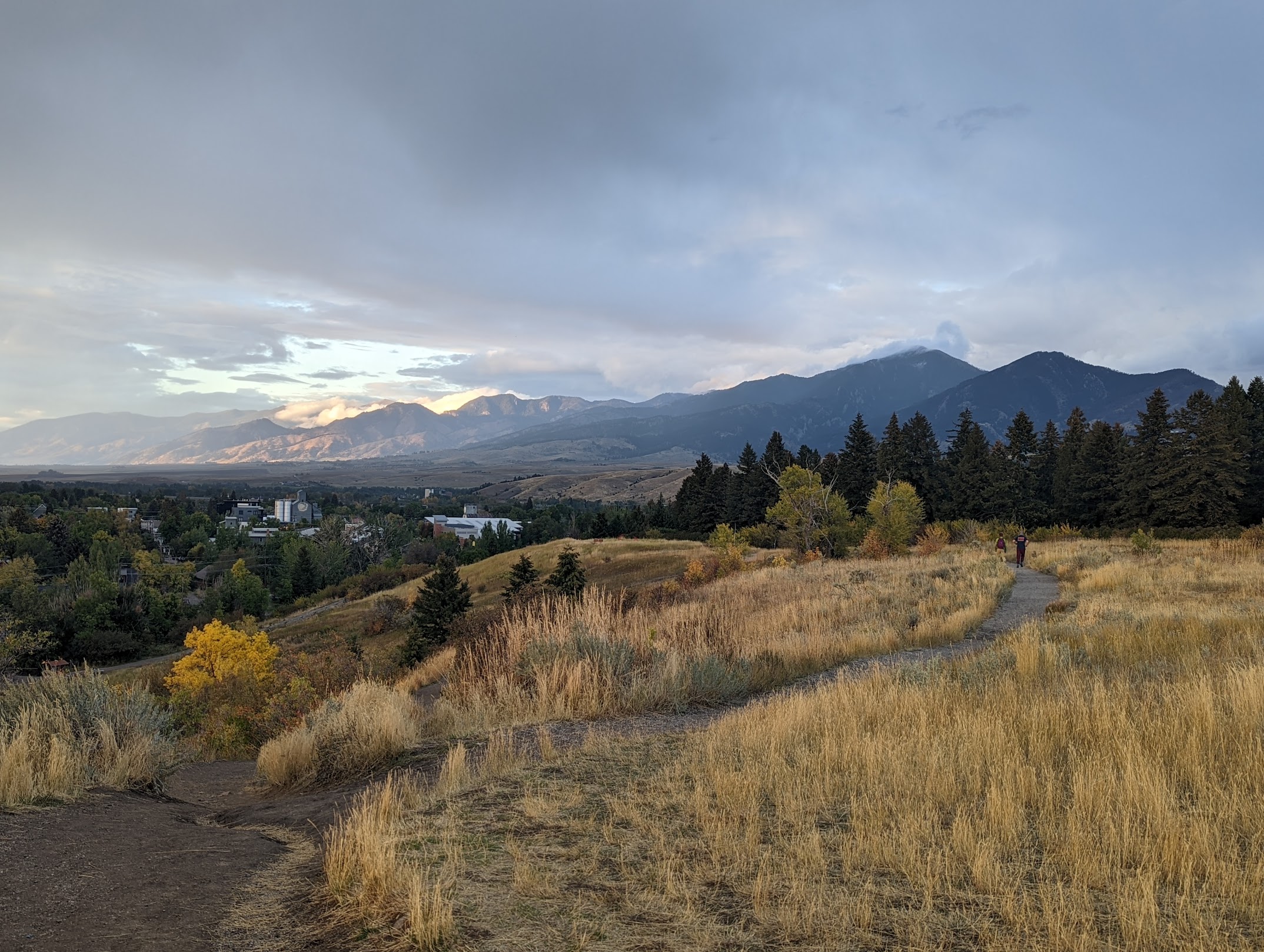
Sourdough / Bozeman Creek Trail is worth doing in fall specifically for the canyon drainage. The trail follows an old road grade along Bozeman Creek, and the aspen groves lining the creek go bright yellow in September. Moose sightings along the water are common enough that it’s worth keeping your eyes on the creek. You can turn around whenever you want, which makes it a good shoulder-season option when you’re not ready to commit to a full alpine day.
Garnet Mountain (8 mi, Strenuous) fire lookout has long views toward the Spanish Peaks and the Gallatins in fall color. It’s a strenuous climb, but the sweeping panorama from the summit during the fall transition is hard to match.
Lava Lake (5.5 mi, Moderate) in the Spanish Peaks has a specific fall quality that comes from the wildfire burn corridor the trail passes through. The lack of canopy opens up the views considerably, and the regenerating forest in October has its own character.
Winter: Avalanche Avoidance and Accessibility
Most of the trails on this site are not winter trails. The same alpine cirques and exposed ridgelines that make Montana hiking spectacular in summer become genuinely dangerous in winter, not because of cold, but because of avalanche terrain.
Avalanche slides rarely initiate on slopes less than 30 degrees. The problem is that many approach trails to the destinations on this site cross avalanche runout zones, pass below steep terrain, or gain enough elevation that the route moves into loaded terrain. Safe winter hiking means understanding slope angle, aspect, and what’s sitting above you on the hillside, not just the trail conditions underfoot. If you’re not trained in avalanche terrain assessment, the winter hiking options on this list are the right call: flat canyon bottoms, low-angle road grades, and forested valleys where the terrain never enters the danger zone.

The positive case for winter hiking near Bozeman is real. Consolidated snow on a packed trail is excellent terrain for microspikes or snowshoes, the crowds are a fraction of summer levels, and certain destinations, frozen waterfalls in particular, are genuinely better in winter than any other season.
Best winter trails:
Palisade Falls (1.1 mi, Easy) is the destination in winter. Hyalite Canyon Road is plowed to the falls trailhead year-round, the trail is short and paved, and the 80-foot waterfall freezes into columnar ice formations that are impressive by any standard. Bring microspikes because the paved trail gets walked on and packed into ice. This is one of those hikes where the winter version is better than the summer version.
Sourdough / Bozeman Creek Trail follows a wide, low-angle old road grade through a canyon with no meaningful avalanche exposure. The trail runs along the creek, the dense tree canopy holds snow on the branches for weeks after a storm, and the winter trailhead sign and kiosk under a snow load are their own attraction. Microspikes are the right tool when the trail is consolidated. The trailhead is 15 minutes from downtown and the trail is skiable or hikeable through most of the winter.
Ousel Falls in winter is worth the drive to Big Sky. The shaded canyon keeps ice formations intact into February during cold spells, and the falls are accessible year-round. The forested trail with snow in the trees is a different experience than the summer version.
Kirk Hill is the close-to-town option, but come prepared. The same north-facing canopy that makes it cool and shaded in summer means the steep sections turn into ice chutes in winter. Microspikes are mandatory from December through March, and the descent on packed ice requires attention. The old-growth Douglas fir under a snow load is worth the short drive from South 19th if you’re comfortable with the conditions.
Seasonal Cheat Sheet
| Season | Accessible Trails | Key Notes |
|---|---|---|
| Early Spring (Mar–Apr) | Drinking Horse, The M, Kirk Hill (once dry) | South-facing slopes only, freeze-thaw mud is trail-damaging |
| Late Spring (May–Jun) | Add Grotto Falls, Pine Creek Falls, Ousel Falls | Hyalite Canyon Road opens May 15, high alpine still snow-covered |
| Summer (Jul–mid Sep) | Full range of trails on this site | Alpine window mid-July through early September |
| Fall (Sep–Oct) | Full range until first major snow | Rut season awareness, orange required in rifle season, peak foliage late Sep |
| Winter (Nov–Mar) | Palisade Falls, Sourdough Canyon, Ousel Falls, Kirk Hill | Microspikes required, stay out of avalanche terrain |