Looking for the best hikes in Bozeman? Start here. This planning guide narrows the site’s 28 Bozeman-area trail guides into the choices that matter most: quick trails close to town, full-day Hyalite hikes, Big Sky and Gallatin Canyon options, wilderness routes, and farther-out solitude fixes.
If you’ve spent any time looking at photos of Bozeman online, you probably have a specific picture in your head: you, alone on a rugged alpine ridge, miles from civilization, breathing in the solitary frontier air.
The mountains look exactly like the photos. The trailheads, however, do not.
Bozeman is one of the most outdoor-obsessed communities in the country, and the trails close to town reflect that. Before you click through to any of the specific guides below, there are four things you need to understand about hiking here.

Four Things to Know Before You Hike Here
1. The Solitude Myth and the 8 AM Rule
Hiking here is not just a weekend hobby for locals. It is a Tuesday morning pre-work routine. If you show up to The M, Drinking Horse Mountain, or anywhere in Hyalite Canyon at 10 AM on a Saturday, you will be fighting for a parking spot and sharing the trail with a steady stream of people, dogs, and strollers.
Real solitude exists, but you have to earn it. Set your alarm for dawn, or drive an hour or more out of town into the Tobacco Roots, the Crazy Mountains, or the deep Spanish Peaks. Treat the trails close to town as social experiences and they will not disappoint. Treat them as wilderness, and they will.
2. Multi-Use Means Multi-Speed
You are not just sharing the trail with other hikers. Bozeman trails are active corridors for mountain bikers, trail runners, off-leash dogs, and horseback riders. Trail etiquette is a safety requirement here, not just a courtesy.
The hierarchy: bikers yield to hikers, everyone yields to horses, and uphill traffic always has the right of way. The practical reality: it is very hard to stop a mountain bike bombing down a steep, rocky trail. Keep your earbuds out, listen for bells, and step aside early.
3. Mud Season Is Not a Suggestion
Spring in Bozeman means thick, shoe-sucking clay, not wildflowers. When visitors hit a muddy section blocking the trail, the instinct is to walk around it. Do not do this. Walking around puddles kills fragile vegetation and permanently widens the trail, leaving behind the ugly braided paths you see on the worst-maintained trails in the country.
The rule is simple: walk through the mud, or turn around and go home. If you are not prepared to get your boots dirty, stay off the dirt trails until June.
4. Bear Spray Is Not a Gear Shop Upsell
Bozeman has good coffee shops and a lively downtown, and it is easy to forget where you actually are. You are at the northern edge of the Greater Yellowstone Ecosystem. Grizzly bears, black bears, and moose do not stay in the backcountry. They wander onto trails fifteen minutes from Main Street.
Bear spray is not a gimmick. Every local you pass will have a canister on their chest or hip. Buy it before you go, know how to pull the safety clip, and keep it accessible — not buried at the bottom of your pack. Our bear spray guide covers everything you need to know.
Where to Start
If you have two hours: The M Trail (3 mi, Moderate) is the most honest introduction to Bozeman hiking. Moderately steep, out-and-back, and the 360-degree view of the Gallatin Valley from the top instantly explains why people move here. It is also reliably crowded, which is part of the experience. Go before 8 AM if you want a quiet version of it.
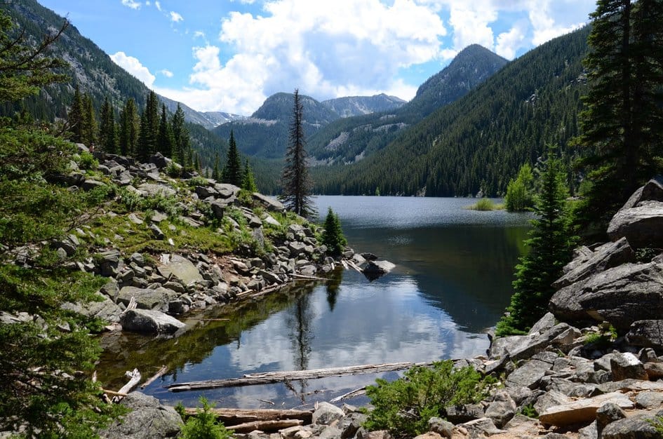
If you have a full day: Hyalite Lake (12 mi, Moderate) is the one. It takes you past 10 waterfalls, gains nearly 2,000 feet through Hyalite Canyon, and finishes at a high alpine lake ringed by rocky cliffs. It is the kind of hike that makes people rearrange the rest of their Bozeman trip to come back for more.

All 28 Trails, By Region
Bozeman & The Bridger Range
The Bridger Range runs directly north of Bozeman. These trailheads are close to town, busy on weekends, and range from quick after-work loops to full-day ridge climbs.
The M Trail (3 mi, Moderate): Bozeman’s calling card. Steep enough to be a real workout, short enough to finish before noon. Views of the Gallatin Valley from the top are the ones you’ve seen in every Bozeman photo.
Drinking Horse Mountain (2.3 mi, Moderate): A short loop just across the road from The M, with better views and fewer people. A good fallback when The M parking lot is already full at 7 AM.
Sourdough / Bozeman Creek Trail (18 mi total, Easy to Moderate): The longest trail accessible directly from town. Most people treat the first few miles through Bozeman Creek canyon as an out-and-back, which is beautiful and easy. The full trail climbs into the mountains and gets serious fast.
Fairy Lake to Sacagawea Peak (4.5 mi, Strenuous): The highest point in the Bridger Range at 9,665 feet. A rough Forest Service road to the Fairy Lake trailhead cuts out most of the elevation gain, but the final push to the summit is exposed and rocky. Worth it on a clear day.
Bridger Bowl to the Ridge (5 mi, Strenuous): The summer version of the ski area’s famous ridge. Big elevation gain, exposed terrain above the lifts, and panoramic views that extend to the Absarokas.
Hyalite Canyon
Twenty minutes south of Bozeman, Hyalite Canyon holds more trail options than anywhere else in the immediate area. In winter it is the most concentrated ice climbing area in the lower 48. In summer it is where most Bozeman hikers spend their weekends.
Be Advised: Hyalite Canyon Road closes annually from April 1 to May 15. None of these trails are accessible by car during that window.

Palisade Falls (1.1 mi, Easy): The most-visited hike in Hyalite. A paved, wheelchair-accessible trail to an 80-foot waterfall dropping off a volcanic rock wall. Short enough for young kids, dramatic enough to be worth it at any age. Arrive early. TripAdvisor has ranked it among the top things to do in the Bozeman area, which tells you everything you need to know about the crowd levels by 10 AM.
Grotto Falls (2.5 mi, Easy): A quieter alternative to Palisade Falls with a shaded forest walk and a shallow pool at the base. Less visited, slightly longer, and more of a forest experience.
For a waterfall-only comparison across Hyalite, Big Sky, Paradise Valley, and farther-afield Montana options, use the Best Waterfall Hikes Near Bozeman planner.
Emerald & Heather Lakes (11 mi, Moderate): Two back-to-back alpine lakes near the head of Hyalite Canyon. Longer than most day hikers expect, but the progression from forest trail to open alpine terrain to two jewel-colored lakes at the top is hard to match anywhere this close to town.
Hyalite Lake (12 mi, Moderate): The crown jewel of Hyalite Canyon. Ten waterfalls on the way up, a high alpine lake at the end, and enough elevation gain to make it feel earned. Our top recommendation for a first full-day hike near Bozeman.
Mount Blackmore (11.6 mi, Strenuous): The most demanding peak in Hyalite at 10,154 feet. The final ridge section is off-trail and exposed. Check conditions before attempting in spring — late snow lingers well into June.
Big Sky & Gallatin Canyon
Highway 191 through the Gallatin Canyon runs 45 miles south from Bozeman to Big Sky Resort. The trailheads along this corridor access some of the most dramatic terrain in the state.

Ousel Falls (1.6 mi, Easy): A short, forested trail to a powerful waterfall on the South Fork of the West Fork of the Gallatin River. Easy enough for all ages and abilities, with the trailhead right in Big Sky town.
Tumbledown Lake (11 mi, Moderate): A longer out-and-back in the Madison Range with a genuinely remote feel that the closer Gallatin Canyon trails lack. Less foot traffic, a beautiful high lake at the end, and real quiet.
Storm Castle Peak (5 mi, Strenuous): A limestone summit hike in the Gallatin Canyon that gains nearly 1,900 feet in 2.5 miles. The peak genuinely looks like a castle, with jagged turrets, a natural arch you can climb through, and 360-degree views of the river canyon far below. Bring trekking poles for the descent and start early before the south-facing rock face turns into a solar oven by midday.
Beehive Basin (6.3 mi, Moderate): Ranked among the best hikes in the world by several outdoor publications, and for once the hype is close to accurate. The trail climbs through wildflower meadows to an alpine basin with Lone Peak towering above it. This is the one that makes people rearrange flights to come back to Montana.
Windy Pass (6.9 mi, Moderate): A quieter alpine day hike off a rough Forest Service road that filters out most casual visitors. The trail follows Portal Creek through forest to a cascade and waterfall, then opens into wide meadows at the Gallatin Crest. The 1934 Windy Pass Cabin in the upper meadow is one of the most memorable things on any trail in this area. High-clearance vehicle required to reach the trailhead.
Spanish Peaks & Madison Range
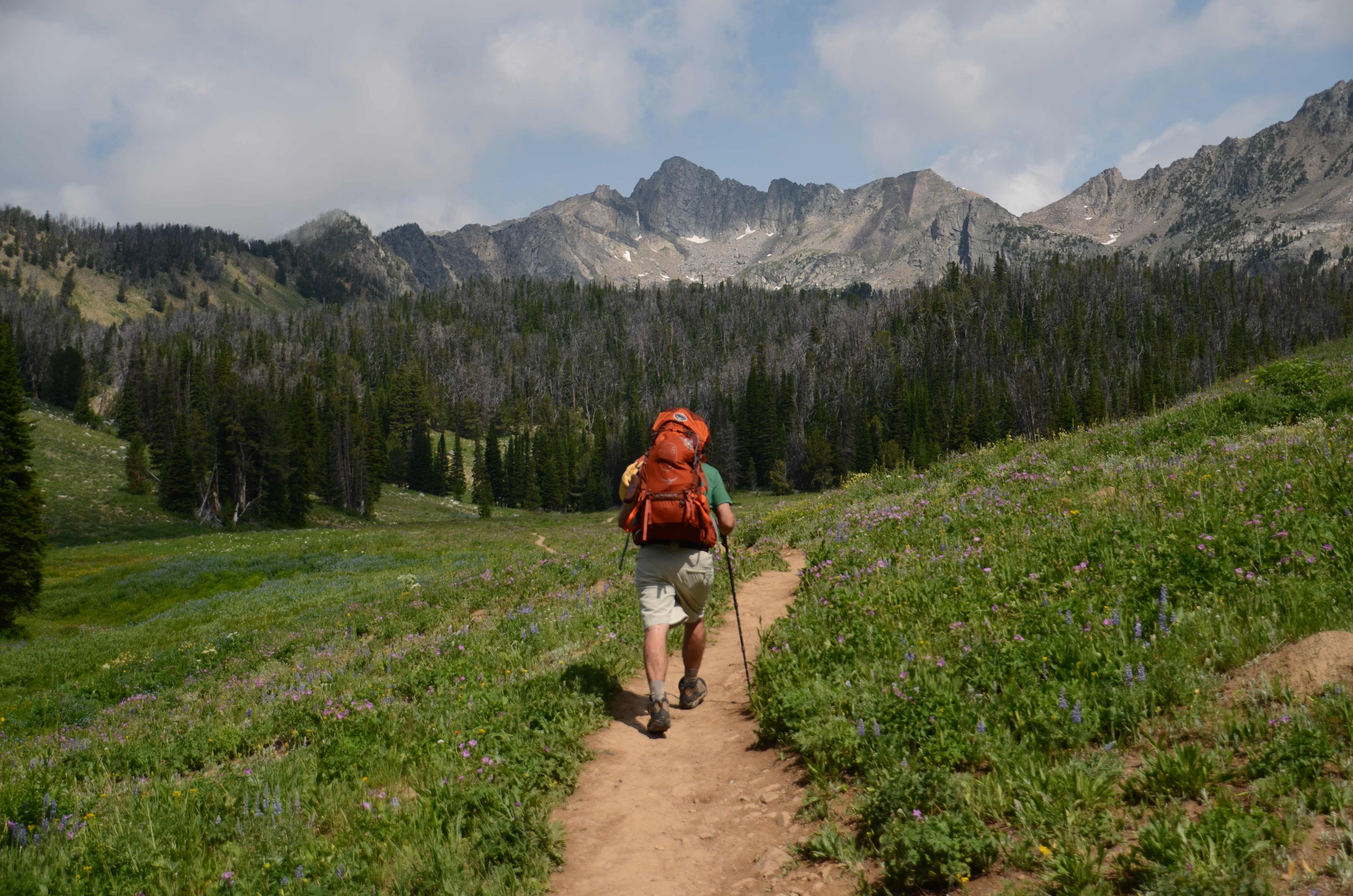
Southwest of Bozeman, the Spanish Peaks Wilderness holds some of the most dramatic backcountry terrain accessible from town. These hikes are longer and more remote than Hyalite. Plan full days and expect slower, rougher access roads.

Lava Lake (5.5 mi, Moderate): The most popular hike in the Spanish Peaks and one of the best moderate day hikes near Bozeman. The trail climbs through a fire-burned forest (which opens the views considerably) to a clear alpine lake. A consistent top recommendation for visitors.
Mirror Lake (15 mi, Moderate to Strenuous): A long day hike to a remote high lake in the Spanish Peaks. The distance keeps the crowds down considerably compared to Lava Lake. A good option when you want the Spanish Peaks experience with more breathing room.
Spanish Lakes (15.2 mi, Strenuous): A serious day hike or overnight trip to two remote alpine lakes in the heart of the Spanish Peaks Wilderness. Bring a map and know how to use it.
Paradise Valley & Absaroka-Beartooth
Paradise Valley runs south from Livingston through some of the most scenic river corridor in Montana. The trailheads here give access to the Absaroka-Beartooth Wilderness and make for natural stops on a Yellowstone day trip.
Pine Creek Falls (2.5 mi, Easy): A short, rewarding hike to a waterfall in Paradise Valley, about an hour from Bozeman. Easy enough for most abilities, with a good parking situation and a great stop on the way to or from Yellowstone’s north entrance.
Pine Creek Lake (11 mi, Strenuous): The full trail continues past Pine Creek Falls and climbs steeply to a remote alpine lake in the Absaroka-Beartooth. Big elevation gain, exposed upper sections, and a genuine all-day commitment.
The Beaten Path (26.6 mi, Moderate to Strenuous): A 26-mile wilderness traverse across the Absaroka-Beartooth with 27 named lakes along the route. Best done as a three-day backpacking trip. If you are a serious backpacker looking for a signature Bozeman-area route, this is it.
The Crazy Mountains
The Crazies are an isolated range about 75 miles northeast of Bozeman, rising abruptly from the high plains east of Livingston. They look like they should not be there. The trailheads are not crowded. The hikes are serious.
Blue & Granite Lakes (9 mi, Moderate): The most accessible introduction to the Crazy Mountains. Two high-elevation lakes in a dramatic cirque, with far less foot traffic than anything in Hyalite or the Spanish Peaks.
Campfire Lake (6.9 mi, Strenuous): A steep, demanding climb to a remote lake with rocky peaks overhead. You will probably not see another person for hours.
Cottonwood Lake (8.2 mi, Strenuous): Another deep Crazy Mountains trail with serious elevation gain and a very remote feel. A natural next step after Blue & Granite Lakes if you want more of this range.
Further Adventures
These hikes are farther from Bozeman, ranging from long day trips to overnight territory.
Garnet Mountain Fire Lookout (8 mi, Strenuous): A strenuous climb to a historic fire lookout cabin in the Gallatin National Forest, bookable through recreation.gov for overnight stays. Serious elevation, a real destination at the top, and almost no competition for trail space. One of the most underrated hikes on the site.
Louise Lake (7.2 mi, Moderate): A solid day hike in the Tobacco Root Mountains about 90 minutes southwest of Bozeman. The Tobacco Roots are consistently underrated. Louise Lake is a good introduction to why.
Hall Lake (9 mi, Moderate): A remote hike in the Swan Valley near Condon, Montana. A long drive from Bozeman, but a reliable solitude fix.
Hidden Lake Overlook (2.7 mi, Easy to Moderate): A Glacier National Park trail to an overlook above one of the park’s most iconic lakes. This is a destination trip, not a day hike from Bozeman, but it is worth every mile of the drive north.
Quick Planning Reference
Best months: July through mid-September covers the full range of trails including high alpine routes. Lower-elevation trails in the Bridger Range and close-in Hyalite open from late May onward in most years, mud season permitting.
Mud season: Late April through mid-June at lower elevations. Walk through the mud or turn around. Do not widen the trail.
Hyalite Canyon Road closure: April 1 through May 15 every year.
Bear spray: Buy it, carry it where you can reach it in two seconds, and read our bear spray guide before you go.
Wildlife: Our Wildlife Near Big Sky guide covers everything you might encounter along Highway 191 and in the Gallatin Canyon.
Permits: No permits are required for day hiking in the Gallatin National Forest, the Spanish Peaks Wilderness, or the Absaroka-Beartooth Wilderness. Leave No Trace practices are strongly encouraged throughout.